
Storm-scale rotation and the supercell model
Where rotation actually lives in a storm, what the word for it means, and why most of it never produces a tornado.
What makes a A thunderstorm with a single rotating updraft that can persist for hours. The storm type that produces most strong tornadoes, very large hail and the most damaging winds. a supercell
One thing: a persistent rotating The column of rising air inside a storm. Everything a thunderstorm does, from hail to tornadoes, is downstream of how strong and how organised this is.. Everything else about the storm follows from that. The Field Guide puts it as two characteristics rather than one, and both are worth having in your own words:
Note that the Field Guide says rain-free base. Module 3 lesson 3 covered why the NWS now prefers updraft base for the same feature, and this module uses the newer term except when quoting.
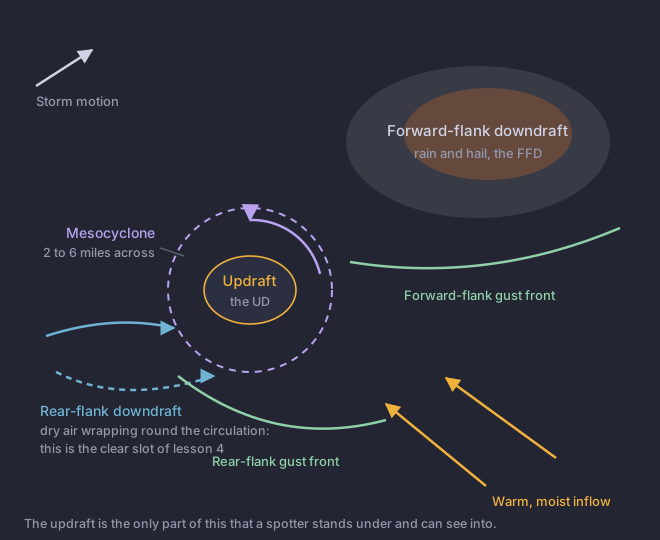
- Updraft
- The rising column. In a supercell it rotates, it persists for hours, and it is the only part of the storm a spotter stands under and can see into.
- FFD
- Forward-Flank DowndraftThe main precipitation area of a supercell, ahead of and to the left of the updraft. Heavy rain and most of the hail fall here.. The main precipitation, falling out ahead of and beside the updraft. This is the part radar reads most cleanly, and the part that hides everything behind it.
- RFD
- Rear-flank downdraft. Dry air descending behind the updraft and wrapping around the circulation. Lesson 4 is about nothing else.
- Gust front
- The leading edge of outflow from either Air descending through and out of a storm, driven by the weight of the precipitation and by rain evaporating into drier air below. It is what produces the gust front and the damaging winds.. Outflow, not inflow, which is the distinction lesson 5 turns on.
- Occlusion
- The stage where the RFD has wrapped far enough around the updraft to cut it off from its inflow. Tornadoes often occur near this point in the cycle.
Mesocyclone is a radar word
This is the correction the whole module is built on, so it gets the glossary in full rather than a paraphrase.
Read the size again: two to six miles across. Standing underneath one, you are inside something wider than your whole field of view, and what you can actually see is a handful of features it produces. A A localized, persistent lowering beneath the updraft base, on the rear inflow side of a storm, marking where air is being drawn up. Not all of them rotate, and a rotating one is what you report.. Curved inflow bands. A A brightening slot of sinking, drying air cutting into the cloud base around the back of a wall cloud. It marks the rear-flank downdraft wrapping in, and it often appears shortly before a tornado.. Those are observations. The mesocyclone is an inference from them, and a radar makes it better than you do.
Most rotation is not a tornado
Trapp, Stumpf and Manross went through more than five thousand mesocyclone detections that met the radar algorithm's own criteria, and asked how many came with a tornado.
Trapp, Stumpf & Manross 2005. The pattern is the useful part: how close to the ground the rotation is detected matters more than whether rotation was detected at all.
The rate at which supercells produce tornadoes is quoted two different ways by two federal sources, and they are given here separately rather than averaged into one confident-sounding number. National Severe Storms LaboratoryA research laboratory, not an operational office. It develops the techniques forecasters use, but issues no products and takes no reports. says as few as 20 percent of supercells produce tornadoes. The Field Guide's supercell page says 30 percent or less. Both are official; neither is a peer-reviewed statistic; quote whichever you are citing and say which.
A spotter radios in: "I have a mesocyclone on this storm." What is wrong with the report?
Think about what the office can do with the sentence once it arrives.SR-145 is explicit that a mesocyclone "should not be considered a visually-observable phenomenon". At two to six miles across it is wider than the spotter's field of view, and the office's radar already detects it better than a person can. What the office cannot get anywhere else is the rotating wall cloud, the funnel or the debris, so that is what goes in the report.