
QLCS, bow echoes, derechos, and mode changes
A line of storms is not a big multicell cluster. It has its own dynamics, its own tornado problem, and a definition dispute running through the middle of it that is worth understanding rather than memorising.
What counts as a Quasi-Linear Convective SystemA long line of storms rather than a discrete cell, often bowing forward. Its tornadoes tend to spin up fast, stay brief and give very little warning.
The term has a radar-based definition, which is what makes the statistics later in this lesson possible. Ashley and colleagues define a QLCS as a convective system with an instantaneous How much of the radar pulse bounced back from whatever the beam was passing through on that tilt. It is the familiar green-to-red precipitation picture, and it describes what is up in the beam, not what is reaching the ground. region of at least 40 The unit radar reflectivity is measured in. Roughly, 20 is drizzle, 40 is a proper thunderstorm core and 60 or more usually means hail., more than 100 km long, with a length-to-width aspect ratio of at least 3 to 1.
- squall line
- The general term for a long, narrow line of convection. Every A long, narrow line of thunderstorms moving as one system. It uses the cold air it produces as its own source of lift, which is how it keeps going for hours. is a QLCS; the newer term exists because it is measurable.
- bow echo
- A segment of the line that has surged forward into a bow or archery-bow shape. The apex of the bow is where the strongest straight-line winds are.
- line segment
- A distinct piece of a line that behaves semi-independently. Lines are rarely uniform, and a spotter watching one is really watching the segment in front of them.
The dome of rain-cooled air a storm leaves sitting on the ground under and around itself. Denser than its surroundings, so it spreads out, and what it spreads under decides whether the storm lives or dies. against Change of wind with height, measured as the difference between the wind at the top and bottom of a layer. It is not needed to make a thunderstorm and it decides almost everything about what kind you get.
Lesson 2 said a cold pool kills an ordinary cell. A line uses it as its engine. The The leading edge of cool air rushing out of a storm, ahead of the rain. It is what makes the wind pick up sharply just before a storm arrives. lifts the warm inflow into the updrafts continuously along its length, and the whole system can run for hours on that arrangement. Whether it does depends on a balance, which is what Rotunno, Klemp and WeismanThe theory describing how a squall line is strongest when the circulation from its cold pool is balanced against the low-level wind shear. Which of the two dominates decides whether the line leans forward, stands upright or leans back and weakens. (Rotunno, Klemp and Weisman 1988) describes.
The cold pool's edge generates circulation in one direction. The low-level environmental shear generates it in the other. Their relative strength sets which way the The column of rising air inside a storm. Everything a thunderstorm does, from hail to tornadoes, is downstream of how strong and how organised this is. leans.
RKW theory as an idealised framework. Real lines move between these states over their lifetime, which is exactly why a line can be a tornado threat for one hour and a wind threat for the next.
The A current of air flowing into the back of a line of storms and descending toward the leading edge. Where it reaches the ground it pushes the gust front forward, which is what makes a line bow. and the bow
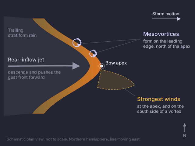
As the system matures, a current of air develops at mid-levels flowing into the back of the line and descending toward the leading edge: the rear-inflow jet. Where it reaches the surface it pushes the gust front forward faster than the rest of the line can keep up, and that segment bows out. The apex of the bow is therefore where the strongest straight-line winds land, which is the single most useful nowcasting fact in this lesson.
A small, shallow circulation along the leading edge of a line of storms, and the source of most tornadoes that lines produce. They spin up in a minute or two, often between one radar scan and the next.
QLCS tornadoes do not come from a The rotating updraft inside a supercell, typically a few miles across. Radar can see it aloft; whether anything is rotating at the ground is a separate question. in the lesson 6 sense. They come from mesovortices: small, shallow, vertical circulations that develop along the leading edge of the line, typically north of the bow apex. They spin up fast, often in less than the time between two radar volume scans, and they can produce a tornado within a couple of minutes of first appearing.
Their damaging winds concentrate on the south side of the circulation, where the vortex flow adds to the system-relative flow rather than opposing it. A mesovortex can therefore produce a swath of wind damage that is not a tornado at all, right beside a track that is, which is why QLCS damage surveys are hard and why module 5 spends time on them.
How many tornadoes come from lines
Trapp and colleagues classified all 3,828 US tornadoes from 1998 to 2000 by parent storm mode. 18% came from QLCSs, 79% from cells, and 3% from other types, mostly The general term for a tropical depression, tropical storm or hurricane. Their outer rainbands produce small, shallow supercells that are a recognised tornado threat well away from the centre. rainbands. QLCS tornadoes skewed weaker: more F1, fewer F2 and F3.
Later work with a longer record and a radar-based classification found that "over 21% of tornadoes, 28% of severe winds, and 10% of severe hail reports are due to QLCSs across the central and eastern United States" (Ashley et al. 2019). Regional variation is very large: in Indiana, QLCSs accounted for 50% of tornado days.
Set that beside lesson 6's figure that supercells produced 97% of tornado fatalities. QLCSs produce roughly a fifth of the tornadoes and a small fraction of the deaths, and they are still the harder warning problem. Both things are true, and confusing frequency with consequence in either direction gets people hurt.
The warning problem
QLCS tornadoes have lower probability of detection and shorter How long between a warning being issued and the severe weather arriving. Quoted two ways: counting only the warnings that beat the event, or averaging in the events nobody warned at all, which roughly halves it. than A thunderstorm with a single rotating updraft that can persist for hours. The storm type that produces most strong tornadoes, very large hail and the most damaging winds. tornadoes. The reasons compound: the circulations are small, shallow and short-lived, so a beam at any distance is above them; they spin up between volume scans; and there is a line of severe weather already in progress, so nothing about the situation stands out.
All of that is worse in the Southeast, because our QLCS tornadoes are disproportionately nocturnal and cool-season, in the High Shear, Low CAPEAn environment with strong wind shear and very little instability, common in the Southeast in the cool season and at night. It produces shallow storms that radar struggles to see and warnings often miss. environments lesson 7 defined. The PERiLS project ran the first field campaign dedicated specifically to QLCS tornadoes in 2022 and 2023, which tells you how recently this became a research priority in its own right rather than a footnote to supercell work.
The Three Ingredients Method
Schaumann and Przybylinski proposed an operational checklist for when a line is likely to produce mesovortices. Three ingredients:
- The cold pool and the low-level shear are near balance or slightly shear-dominant, the middle row of the RKW table above.
- 0 to 3 km line-normal shear of at least 30 kt. Line-normal means the component perpendicular to the line, not the total, which is a cosine away from the number on the A vertical profile of temperature, moisture and wind through the atmosphere, from a weather balloon or a model. Everything in this section is read off one..
- A rear-inflow jet or enhanced outflow producing a surge or a bow.
A long-lived, fast-moving windstorm produced by a line of thunderstorms, leaving damage in a swath rather than at scattered points. One of only two things that can put an area under a HIGH risk.: three definitions and a live argument
A derecho is a widespread, long-lived convectively generated windstorm. What counts as one has been redefined twice, and the reason is worth more to you than the thresholds.
The 2025 definition is the current standard, and Storm Prediction CenterThe national office in Norman, Oklahoma that issues severe weather outlooks, mesoscale discussions and watches. It does not issue warnings. updated its derecho pages to it. Johns & Hirt remains the historical origin and is still where the 400 km figure comes from.
Storms change mode
Nothing in this module is a permanent label. The commonest transitions in the Southeast:
- Discrete to linear. Cells initiate ahead of a front, then merge into a line as the front catches them. The tornado threat is often highest during the transition, while discrete rotating storms still exist inside the developing line.
- Supercell to bow. A supercell whose cold pool outgrows its shear stops being a supercell and becomes the north end of a bowing segment. The threat changes from tornado to swath wind, and it changes fast.
- High Precipitation supercellA supercell whose precipitation wraps around and can completely hide the updraft. Rain-wrapped tornadoes and flash flooding, and the common mode on the Gulf Coast. upscale growth. An HP supercell that keeps merging with the convection around it becomes a system. This is the same transition seen from the other end.
Which is why mode identification is a running task rather than a call you make once. The storm you reported forty minutes ago may no longer be the kind of storm you reported.
Locally
The reference case for this lesson is 12 January 2023. NWS Mobile storm surveys confirmed an EF-2 in Mobile County, an EF-1 in Crenshaw County, an EF-0 in Conecuh County and an EF-U in Covington County, alongside a 60 to 90 mph straight-line wind swath along the I-65 corridor from Conecuh into southeast Crenshaw. Cool season, HSLC, tornadoes and a wind swath from the same line: every part of this lesson in a single afternoon, in our own counties.
A line is bowing, and you are trying to work out where the tornado risk is highest within it. Where do you look?
The apex and the mesovortices are not in the same place, and the question asks about only one of the two hazards.Mesovortices are favoured north of the bow apex, and they are where QLCS tornadoes come from. The apex is where the rear-inflow jet reaches the surface, so that is where the strongest straight-line winds are. Two hazards, two different places along the same feature, and a report is much more useful when it says which one you saw.