
When the network fails
Cellular fails in severe weather, and there is data. A four-layer plan, a kit, and the sentence about when not to use this app.
It is not hypothetical
The August 2020 Midwest A long-lived, fast-moving windstorm produced by a line of thunderstorms, leaving damage in a swath rather than at scattered points. One of only two things that can put an area under a HIGH risk. is the case with numbers attached, because the federal regulator activated its disaster reporting system and counted. Module 9 lesson 10 covered the meteorology; this is what it did to the phones.
Note the breakdown: only five sites were physically destroyed. Almost everything that failed did so because the power went or the connection back to the network went. That is why it recovers over days rather than weeks, and why it fails over a huge area at once.
Two things that follow
- Text beats voice under load
- A voice call needs a continuous channel for its whole duration. A text message is a tiny packet that can wait for a gap and retry. When a network is congested rather than down, short messages frequently get through when calls will not. Try text before concluding you have no service.
- Congestion is not the same as outage
- A site with no power is gone. A site that is up but swamped will eventually pass your traffic. They feel identical on a handset, and they call for different responses: wait and retry against switch to another layer entirely.
A four-layer plan
Borrowed, like module 8 lesson 8, from people who solved this before us. primary, alternate, contingency, emergencyA communications resilience method: decide four channels in advance and move down as each fails. The discipline is that each layer must fail for a different reason, so two that share infrastructure are really one. stands for primary, alternate, contingency and emergency, and the discipline is that you decide all four in advance and move down the list as each fails.
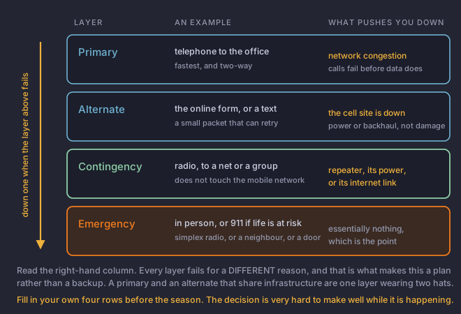
Yours will differ and should. Somebody with no radio licence might use a neighbour with one as their contingency layer. The exercise is filling in four rows that fail independently.
The kit
- A NOAA Weather RadioThe National Weather Service broadcasting its own products directly on dedicated radio frequencies. It keeps working when the internet and the phone network do not.. It receives when nothing else does, it does not depend on the mobile network at all, and it is the answer to the siren problem in lesson 5.
- A power bank, charged, and a way to charge from the car.
- Any radio you have, programmed in advance, with the local net frequencies and the Radio directly to radio with no repeater in between. Much shorter range, and the fallback when the repeater or its power or its internet link has gone. fallback already in it. Programming a radio in the dark during a storm is not a plan.
- Paper. A notebook and a pen, so a report survives a dead phone and so you can log a time immediately.
- Offline maps, so you can still give a location when the map app cannot load.
Where this platform sits
That is worth stating in a course this platform publishes, because a course that soft-pedalled it would be serving the platform rather than the reader. A spotter whose plan is one app has the same problem as a spotter whose plan is one phone.
What a structured digital report is genuinely good at is capturing the things people forget: the position with its accuracy, the time of occurrence kept separate from the time you pressed submit, the measured or estimated tag, and a photograph with its metadata intact. Module 7 lesson 6 listed those as things to remember; a form remembers them for you.
Photographs, and the ones that are not real
Offices actively monitor social media and act on what they find. They also warn about the recurring problem: false reports cause delays, and images from events months or years old circulate during every significant event. Generated images have made this considerably worse.
- When was it taken? Not when was it posted. Ask directly, and treat a vague answer as an answer.
- Where was it taken? Does the terrain, the vegetation, the architecture and the light match the place it is claimed to be?
- Who took it? A first-hand account from somebody you can ask a follow-up question of is worth more than a dramatic image from nobody.
- Does it match the physics? Module 3 and module 4 taught you what these features actually look like. A great deal of fake imagery does not survive a careful look at the cloud base.
You are watching a tornado on the ground in a populated area. You have this app open on your phone and a signal. What is the correct first action?
This course is published by the platform in the second option, which should make you more suspicious of it rather than less.Life at risk means the official channel, directly. A third-party platform complements the NWS channels and does not replace them, and that is true of this one. The fourth option is not unreasonable afterwards, but the ordering matters: make the call first, then file the structured report when you are safe and have time.