
How hail is made
Wet growth, dry growth, and the updraft that has to hold a stone up long enough to build it. Plus the two pieces of hail folklore worth unlearning first.
One stone, two kinds of ice
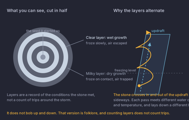
A hailstone starts as something small carried above the The height at which the air reaches 0 °C. A hailstone has to survive the fall from there to the ground, so a high freezing level means more melting and smaller hail at the surface., and grows by collecting supercooled water that freezes onto it. How fast that water freezes decides what the ice looks like, and National Severe Storms LaboratoryA research laboratory, not an operational office. It develops the techniques forecasters use, but issues no products and takes no reports. puts the distinction plainly: water that freezes instantly on contact traps air and makes cloudy ice; water that freezes slowly lets the air escape and makes clear ice.
How fast it falls, and what that costs the updraft
For a stone to grow, the updraft has to hold it up. That is the whole relationship between hail size and storm strength, and the fall speeds are the reason it is so demanding at the top end.
NSSL figures. Higher numbers circulate for golf balls and softballs, and they come from secondary sources rather than NSSL; this course does not use them.
So a storm producing four-inch hail is holding up something falling at seventy miles an hour, and doing it long enough to build the stone. The configuration that manages it consistently is the broad, persistent, rotating, tilted A thunderstorm with a single rotating updraft that can persist for hours. The storm type that produces most strong tornadoes, very large hail and the most damaging winds. updraft from module 4. Tables that convert a specific updraft speed to a specific hail size are not NWS figures and are not reproduced here.
Where the hail comes down is structure, not chance: the hail core sits near and forward of the updraft, on the forward flank, which is the same part of the storm module 4 called the Forward-Flank DowndraftThe main precipitation area of a supercell, ahead of and to the left of the updraft. Heavy rain and most of the hail fall here.. Between 40 and 70% of what forms aloft can melt before it reaches the ground, which is a footnote here and the whole story in lesson 8.
Green sky
Green storms are real. Gallagher, Beasley and Bohren measured them, and Bohren and Fraser worked out the optics. What the research did not find is any reliable relationship between the colour and hail size, or between the colour and tornadoes.
A hailstone cut in half shows six alternating clear and cloudy layers. What can you conclude?
One of these is the folklore version, and NSSL corrects it by name.The layers record conditions, not trips. NSSL is explicit that layering comes from horizontal passage across and near the updraft, not from cycling up and down, so counting layers tells you nothing about how many times the stone went round.