
Where your report actually goes
Five stages, one of which is preliminary and one of which is permanent, and the documented reasons the archive is not a fair sample of what happened.
The five stages
Your report does not arrive somewhere and stop. It moves through a chain, and at two points along it a human being can change what it says. Knowing where those points are is what tells you which parts of your report have to be right the first time.
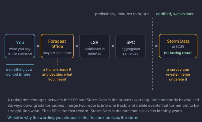
- You. A phone call, a form, a net. What you say is the only evidence that exists at this point.
- The forecast office. A forecaster reads it, decides whether it is plausible and what it means, and may act on it immediately in a warning.
- The Local Storm Report. The office publishes it, often within minutes. This is the version the world sees first.
- Storm Prediction CenterThe national office in Norman, Oklahoma that issues severe weather outlooks, mesoscale discussions and watches. It does not issue warnings. preliminary reports. Aggregated nationally the same day, which is where the familiar dots-on-a-map come from.
- The official national archive of significant weather events and their impacts, published by NOAA and built largely from local storm reports. It is the source almost every long-term severe weather statistic comes from.. Weeks to months later, after quality control, into the national archive at National Centers for Environmental InformationThe NOAA archive that holds the certified Storm Data record, among a great deal else. When somebody quotes a long-term severe weather statistic, this is almost always where it came from.. This is the version that still exists in thirty years.
Preliminary is not a hedge, it is a status
NWS Instruction 10-517 says it in two sentences and they are worth reading carefully, because a great deal of public confusion comes from skipping them:
LSRs are preliminary in nature. The final report of verified weather
events will be listed in monthly Storm Data reports in accordance with
NWSI 10-1605.
Local offices say the same thing on their own event pages. The Mobile office's page for the 10 May 2025 tornadoes, which lesson 2 uses as a worked example, carries this while the surveys were still being revised: "The data provided on this page are considered PRELIMINARY as we continue to analyze all available data." That is a forecast office telling you, in advance, that its own numbers will move.
What is actually in a Local Storm Report
An LSR is a fixed set of fields, and every one of them is something you either supplied or the office had to guess. That is the reason to know the list.
The magnitude field carries a tag of Measured, Estimated or Unknown, a format in place since 8 February 2006. Unknown is what you get when you do not say, and it is the weakest of the three.
Why the archive is not a fair sample
Storm Data is built from reports, and reports are made by people, so the archive records where people were as much as where the weather was. This is measured, not suspected.
- Population. More people means more reports of the same event. Allen and Tippett found this plainly in the hail record.
- Roads. A tornado crossing a highway is seen. The same tornado two miles into timber is not.
- Distance from the office. Reporting density falls off with range from the Weather Forecast OfficeA local National Weather Service office. It issues the warnings for its own area, and it is the office your report reaches., which is a property of the reporting network rather than of the weather.
- Night. The single largest gap, for the obvious reason.
Potvin and colleagues put a number on how far this goes: modelling the tornado database, they estimated that in some rural areas only about 45% of tornadoes are reported at all. More than half of them simply are not in the record.
What this platform does with it
Every report submitted here is checked against radar and the surrounding data for plausibility. Module 5 said it for hail and wind and module 6 said it for flooding, and the rule is the same one: a report that disagrees with the radar is flagged for a human to look at. It is never automatically thrown away.
The instruction the offices work to reasons the same way. Storm Data quality control reconciles report times against radar signatures, and the directive is explicit about what the archive is for: "the primary purpose of Storm Data is to accurately describe events, regardless of the impact on Checking afterwards whether warned events happened and unwarned ones did. It leans almost entirely on reports, which is why a late report still counts for something. scores." The record is meant to be true, not flattering. Lesson 5 is about what you can do to make yours survive that check.
A Local Storm Report from last night lists an EF2 tornado. Three weeks later Storm Data lists the same event as EF1. What happened?
One of the five stages is described by its own directive in a single word.NWS Instruction 10-517 states that LSRs are preliminary and that the final report appears in Storm Data. A rating changing between the two is the process working exactly as designed, and it reflects a damage survey rather than any judgement about the person who called it in.