
Flooding is local
The same rainfall floods five places five different ways. Which one you live in decides what to watch, what to expect, and which rules of thumb will mislead you.
Rain does not flood places. Catchments do.
Lesson 2 gave you the rainfall. This lesson is about what the ground does with it, and the honest headline is that three inches of rain in an hour means something completely different in five different parts of the country. In one it is a wall of water down a canyon inside twenty minutes. In another it is a street that stands under a foot of water for six hours and then drains. In a third it is nothing at all.
Which means the most common failure in flood spotting is applying a rule of thumb learned somewhere else. Most national training material is written around terrain, because terrain floods dramatically and photographs well, and a spotter on a coastal plain or in a flat agricultural county reads it and concludes their area does not really flood. It does. It just does it differently.
Five regimes
Soft boundaries, and plenty of places are two of these at once. The row that matters is the one your own ground is in, and the point of reading the other four is knowing which borrowed rules to distrust.
Three things that are true everywhere
- How wet the ground was before the rain started. It decides how much of the rain becomes runoff, which is why the same storm floods a catchment one week and not the next. decides the share that runs off. The same storm floods a catchment one week and not the next, and nothing about the storm changed.
- Flat drains slowly. Water that arrives fast and leaves slowly stands deeper and longer than water in a valley that empties itself. Slow flooding is not mild flooding.
- Soil type is overwhelmed, not decisive. Sand drains until the rainfall rate exceeds its infiltration rate, which a heavy convective rate does in minutes. After that what the soil is made of stops mattering.
Compound flooding, the coastal special case
One regime has a failure mode the others do not, and it is worth a section because it breaks the arithmetic people use. Compound flooding is heavy rainfall arriving at the same time as elevated coastal water. The rain has to go somewhere, and the somewhere is already above its normal level, so it does not go.
The National Hurricane CenterThe national office for tropical cyclone forecasts and warnings. report on Hurricane Sally puts it in one sentence: "Due to the incoming An abnormal rise of water generated by a storm, over and above the predicted astronomical tide. It is the storm-driven part on its own, which is why it can be quoted as a height without saying anything about how deep the water actually got., extreme rainfall produced by Sally had nowhere to drain, which resulted in widespread flash and river flooding as well."
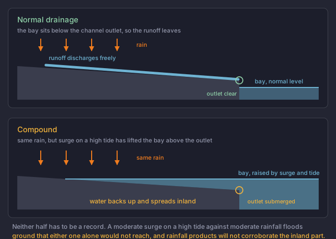
The same mechanism, without a tide, appears inland wherever a tributary meets a main river that is already high. The tributary cannot discharge and backs up, flooding ground the main river never reaches. If you live at a confluence, this lesson is about you too.
What floods first, wherever you are
- Low-water crossings. Built to be overtopped, unmarked as often as not, and the single most common place people drive into moving water.
- Creek, bayou and arroyo banks, where the rise is fast and the banks are low.
- Underpasses and low points in the street grid, which collect urban runoff and give no indication of depth from either approach.
- Confluences and outlets, where the water has to get past something that may not be letting it.
- The place that flooded last time. Local flood history is the best predictor there is, and it is free.
Four inches of rain falls on sandy, well-draining soil over flat ground two miles from a bay, with a two-foot storm surge running on a high tide. Which factor most increases the flood risk?
One of these four changes what happens to the water after it has already reached the ground.This is compound flooding. The rain is unremarkable and the surge is unremarkable, and together they flood ground neither would reach alone, because the raised water level blocks the outlet the runoff needs. Sand does not become impermeable, it is simply overwhelmed, and flat ground drains slowly rather than quickly.