
Dual-pol, and confirming debris
Three new fields, one of which answers a question the old radar could not: is what I am looking at even made of water?
What the upgrade actually did
The old radar transmitted a horizontally polarised pulse and measured what came back. A A radar upgrade that sends pulses both horizontally and vertically, so the returns say something about the shape of what they hit. It is what lets radar recognise lofted debris. radar transmits and receives both horizontally and vertically, and comparing the two tells you about the shape of what it is looking at.
That is a genuine change in kind. How much of the radar pulse bounced back from whatever the beam was passing through on that tilt. It is the familiar green-to-red precipitation picture, and it describes what is up in the beam, not what is reaching the ground. tells you how much is there. The radar product showing how fast the rain, hail and debris in the beam are moving toward or away from the radar. Only motion along the beam is measured, and rotation shows up here as inbound and outbound speeds side by side. tells you how it is moving. The dual-pol fields begin to tell you what it is.
- Differential reflectivity
- Written differential reflectivityHow much stronger the horizontal radar return is than the vertical, which measures the shape of what is in the beam. Large raindrops flatten as they fall and read strongly positive; hail tumbles and averages near zero.. How much more the horizontal return is than the vertical, which is a measure of shape. Large raindrops flatten as they fall and give strongly positive values. Hail tumbles and averages out to near zero. Positive means wide and flat; near zero means round or tumbling.
- Correlation coefficient
- Written How consistently the horizontal and vertical radar returns agree across a sample volume. Rain is uniform and reads near 1; a mixture of very differently shaped things reads low, which is how debris is detected. or rho-hv. How consistently the horizontal and vertical returns agree across the sample volume. Rain is uniform and gives values near 1. A mixture of very different things gives low values, and that is the field that does the work in this lesson.
- Specific differential phase
- Written specific differential phaseDerived from how the phase of the horizontal and vertical signals drifts apart along the path. Sensitive to liquid water content and largely unaffected by hail or attenuation, so it is mostly a rainfall-rate tool.. Derived from how the phase of the two signals drifts apart along the path, which is sensitive to liquid water content and largely unaffected by hail or by attenuation. Mostly a rainfall-rate tool, which is module 6 lesson 6.
The tornadic debris signature
The reason this lesson exists. Debris is not water. Boards, insulation, soil, roofing and vegetation are wildly irregular and differently sized, so the horizontal and vertical returns stop agreeing and the correlation coefficient collapses. A radar can therefore detect that something non-meteorological has been lofted.
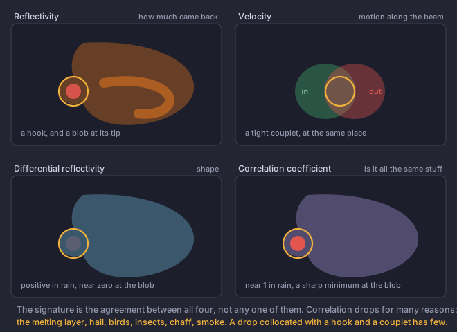
The original criteria from Ryzhkov and colleagues in 2005. Later work relaxed the correlation threshold somewhat, accepting a higher value provided it is a clear local minimum collocated with a strong vortex. The four-part collocation matters more than any single number.
Other things the fields tell you
- Hail
- High reflectivity with differential reflectivity near zero. Rain that reflective would be flattened and strongly positive; hail tumbles and is not. A useful discriminator in the column, and module 5 covers what it does not tell you about size.
- The differential reflectivity column
- A plume of high values extending upward above the The height at which the air reaches 0 °C. A hailstone has to survive the fall from there to the ground, so a high freezing level means more melting and smaller hail at the surface., where a strong The column of rising air inside a storm. Everything a thunderstorm does, from hail to tornadoes, is downstream of how strong and how organised this is. is carrying liquid drops higher than they should be able to go. A proxy for updraft strength, and something forecasters watch for intensification.
- The melting layer
- A ring or band of high reflectivity, high differential reflectivity and reduced correlation at the height where snow is melting: wet, large and irregular all at once. Module 6 lesson 6 covers what it does to rainfall estimates.
- Biological and other non-weather targets
- Birds, bats and insects give very low correlation and often odd differential reflectivity, and they appear in clear air, expanding outward at dusk. Smoke plumes and chaff behave similarly. This field makes them obvious in a way the old radar never could.
You see a small area of correlation coefficient around 0.6 in clear air, 40 km from the radar, expanding outward around sunset. What is it most likely to be?
Three details in the question rule out the debris answer on their own.Clear air, no storm, and an expanding pattern at dusk is the classic biological signature, and it is a good illustration that a correlation drop by itself means a mixture of differently shaped things rather than a tornado. A debris signature requires reflectivity above 45 dBZ collocated with a hook and a velocity couplet, none of which is present here.