
Where to stand
The safe viewing quadrant of a classic supercell, why core-punching is prohibited, and what is inside the notch that looks so inviting.
The quadrant
For a classic Northern Hemisphere A thunderstorm with a single rotating updraft that can persist for hours. The storm type that produces most strong tornadoes, very large hail and the most damaging winds., the position the NWS field guide describes is to the south or south-east of the The smooth, flat, dark cloud base on the rear flank of a storm, where warm air is flowing in and rising. It is named for the air going up, not for being dry: hail and large drops may still fall from it.. Three reasons, and they are worth knowing separately because in a given storm one of them may not hold.
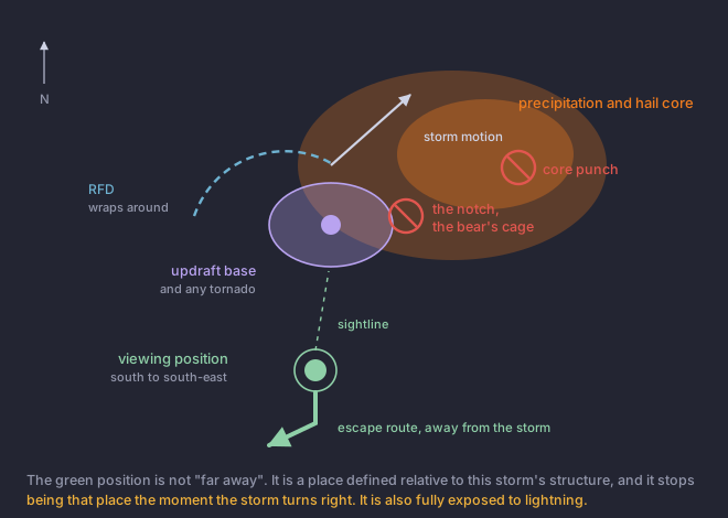
- Contrast. A developing tornado is dark against lighter sky from this side. From the other side it is a silhouette inside rain, which is no view at all.
- Out of the hail. The precipitation and hail core sits on the other flank. Being under it is lesson 6 and a broken windscreen.
- An escape route that leads away. South, generally, away from a storm that is generally moving north-east. An escape route pointing into the storm is decoration.
The storm may not go where you think
A supercell frequently moves to the right of the mean winds aloft, sometimes well to the right, because its rotation makes it propagate rather than simply drift. Module 2 covers the mechanism. What it means here is that your safe quadrant is defined relative to the storm and the storm is allowed to turn.
Core-punching
Driving through the precipitation and hail core to get to the other side of a storm. It is the fastest way between two points and it is prohibited here for four reasons that all arrive at once.
- Very large hail, which takes out a windscreen and leaves you immobilised inside a severe storm with no glass.
- Zero visibility, on a road that is wet or covered in hail, at whatever speed you were doing when it closed in.
- You can drive out of the rain directly into the tornado, because the thing on the other side of a core is often the circulation.
- You cannot see what is coming the other way, and other people are doing the same thing.
The Rear-Flank DowndraftA dry downdraft wrapping around the back of a supercell updraft. One of the two features that distinguish a supercell in the field, and it can produce damaging outflow winds entirely on its own. and the bear's cage
- Rear-flank downdraft
- Dry or wet air descending on the back of the storm and wrapping around the circulation. A wet RFD may carry sustained winds over 100 mph and hail larger than baseballs, and it obscures any tornado inside it. The RFD can do more damage than the tornado does.
- The bear's cage
- The notch between the precipitation core and the The column of rising air inside a storm. Everything a thunderstorm does, from hail to tornadoes, is downstream of how strong and how organised this is., where the A hook-shaped appendage on the reflectivity image, wrapped around the back of a supercell. One of the oldest radar clues that a storm is rotating. shows on radar. It is where the circulation is, wrapped in rain and hail, with no visibility and frequently no way out. On radar it looks like the most interesting place on the storm. On the ground it is the worst place you can be.
Which brings back the distance argument
Every hazard in this lesson is a hazard of proximity, and the temptation behind all of them is the belief that a closer look produces a better report. It does not. Lesson 1 covered why, and this is where it becomes operational: the report does not improve, and distance is free accuracy insurance.
You are south-east of a classic supercell with a good view of the updraft base. The inflow wind at your back increases sharply and the storm appears to be turning right, toward you. What now?
The quadrant is defined relative to the storm, not to the compass.The safe quadrant moves when the storm does, and a right turn plus sharply increasing inflow is both a positioning problem and a possible tornado cue. Option three is a core punch. Option four is the bear's cage. Leaving early costs you a view and nothing else.