
When the playbook does not transfer
Five environments, the assumptions lesson 4 makes that each of them breaks, and the one skill that works in all of them: knowing your roads before you need them.
Four assumptions, quietly made
Lesson 4 works, and it works because of four things it never says out loud. You can see the storm. It is one discrete storm. It is moving slowly enough to position against. You can see the horizon for miles. Those hold on the Plains in the afternoon. They hold in a lot fewer places than the training material implies.
Only the first row matches the diagram in lesson 4. If you are in any of the other four, positioning is a harder problem than the training photographs suggest, and the honest answer is often not to be mobile at all.
Rotation you cannot see
Three overlapping situations produce tornadoes that a spotter has little or no chance of seeing coming, and they are the ones this lesson exists for.
- Rain-wrapped
- The circulation is inside the precipitation. The High Precipitation supercellA supercell whose precipitation wraps around and can completely hide the updraft. Rain-wrapped tornadoes and flash flooding, and the common mode on the Gulf Coast. of module 3 is the usual producer. From outside it is a wall of rain; from inside it you are in the circulation. El Reno was rain-wrapped.
- QLCS spin-ups
- Brief tornadoes along a A long, narrow line of thunderstorms moving as one system. It uses the cold air it produces as its own source of lift, which is how it keeps going for hours., forming and dissipating in minutes with little visual warning. They account for roughly 12% of US tornadoes overall, closer to 18% in the Southeast, and about 23% of tornadoes in the environment described below.
- HSLC
- High Change of wind with height, measured as the difference between the wind at the top and bottom of a layer. It is not needed to make a thunderstorm and it decides almost everything about what kind you get., low Convective Available Potential EnergyHow much energy is available to an updraft, in joules per kilogram. Bigger numbers mean a stronger updraft is possible, and a number on its own says nothing about what kind of storm you get.. Sherburn and Parker define it as roughly CAPE computed for a particular starting parcel: surface-based, mixed-layer or most-unstable. The same sounding can give values a factor of two apart, so the prefix matters more than the number. below 1000 J/kg with 0 to 6 km bulk shear at or above 18 m/s. These environments produce the majority of cool-season and overnight tornadoes and damaging winds, and they are commonest in the Southeast.
The outcome shows up in the fatality statistics. The Southeast's rate of deadly tornadoes is roughly double the national rate, and that is not because the tornadoes are stronger. It is darkness, rain-wrapping, trees, housing stock and short warning time, together.
Night
Ashley and colleagues quantified this and the numbers deserve to be stated plainly. Over 1950 to 2005, 27.3% of tornadoes were nocturnal, and they caused 39.3% of tornado fatalities and 42.1% of killer-tornado events. A nocturnal tornado is about 2.5 times as likely to kill as a daytime one.
The general term for a tropical depression, tropical storm or hurricane. Their outer rainbands produce small, shallow supercells that are a recognised tornado threat well away from the centre. tornadoes
A category of their own, and they reach a long way inland and up the Atlantic seaboard rather than staying on the coast. They come from A supercell with a shallower, smaller and weaker rotating updraft than a classic one, typical of tropical cyclone rainbands. Produces tornadoes in an environment with a fraction of the instability a Plains supercell needs. in the outer rainbands: small, shallow, fast, usually brief, embedded in rain, and arriving during an event that is already producing damaging wind for other reasons.
Which makes them the hardest reporting problem in module 7 and a genuinely bad situation to be mobile in: the roads are already compromised by the parent storm, and a Severe weather is happening or about to happen for the people inside a drawn polygon. Issued by the local forecast office. It means act now. may arrive with minutes of How long between a warning being issued and the severe weather arriving. Quoted two ways: counting only the warnings that beat the event, or averaging in the events nobody warned at all, which roughly halves it. while you are somewhere you cannot quickly leave.
Escape routes, which work everywhere
This is the transferable half of the lesson. Whatever environment you are in, the road network is the thing you can study in advance and the thing that will decide whether a bad moment stays recoverable.
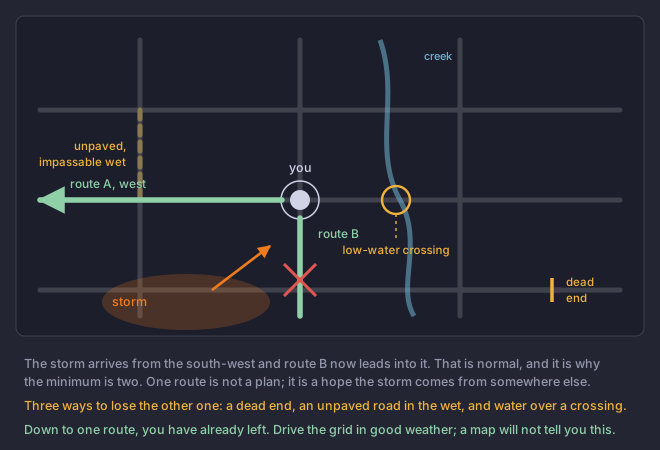
- Always have at least two, going in genuinely different directions. Two roads that converge a mile away are one road.
- Know the grid before the day, not on the day. Drive it in good weather. Which roads actually go through is not reliably shown on a map.
- Mark the dead ends. A road that stops at a gate, a river or a field is where people get caught.
- Mark the unpaved sections, which become impassable in exactly the rain you are out in.
- Mark the low-water crossings and the bridges. Module 6 lesson 3 is about why these go first, and lesson 6 of this module is about what happens if you try one.
- Treat congestion as a hazard, not an inconvenience. A blocked road is a missing escape route, and it blocks the emergency vehicles too.
A rain-wrapped QLCS tornado threat is approaching at night at around 55 mph, in a forested area you do not know well. What is the correct posture?
Count how many of lesson 4's four assumptions are still standing.None of them hold: you cannot see it, it is not discrete, it is far too fast to position against, and there is no horizon. Option two applies a classic-supercell rule to a line at night, when contrast against the sky does not exist. This is the situation the module is building toward, and the answer is that being mobile is the wrong decision rather than a decision to make carefully.